|
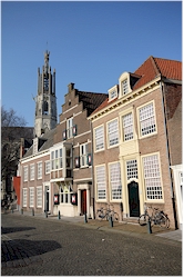
Picture: full terraces in the center of Hulst |
|
» Town walls » Refuge houses » Basilica » Town hall » 's Landshouse » more... » Regional museum » Historical evocation VVV » Saeftinghe » Reynaert De Vos » Nieuwe Bierkaai
|
The town walls of the fortified town of
Hulst Hulst is known as a fortified town; it is one of the very few places in the Low Countries where the town walls have survived up till now in a virtually intact state. They are not only interesting from architectural and strategic point-of-view but they are also an excellent place for the good walk. The historic town center is situated entirely inside these walls.
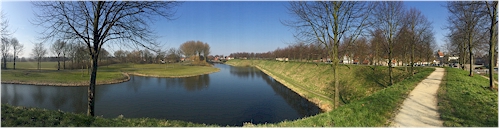
The fortifications still encircle the center entirely and are the largest monument of the town. Should you ever have the fortune to fly over Hulst in a hot air balloon, then you will see the perfect geometric form of the walls and in what perfect condition they have been preserved. As an alternative, you can also have a look at satelite image on the internet but that of course does not give you the same experience. There are walls, ditches and no less then 9 bastions. Only via one of three gates you can access the town.
Hulst remained a garrison town until 1816 when the soldiers quit it. Mainly in the 19th century, in Belgium and the Netherlands, a lot of town walls were levelled to make room for the expansion and renewal of towns. Due to the efforts of the inhabitants and the town council this did not happen in Hulst. As a result Hulst still has its walls and inhabitants and visitors can still enjoy this unique green belt of some 3.5 km around the town.
Picture 1: Panoramic view on
the walls and ditches
|
» How to get to Hulst? » Map of sights » links » Clinge » Graauw » Heikant » Hengstdijk » Hulst » Kapellendijk » Kloosterzande » Kuitaart » Lamswaarde » Nieuw-Namen » Ossenisse » Sint-Janssteen » Terhole » Vogelwaarde » Walsoorden
|

 The
fortifications as they are now date back to the 80 Years War (1568 - 1648)
but Hulst has been fortified since the 12th century, when it
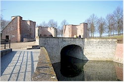
received its town rights. The oldest part of the town
defence that you still can see is the 'Bollewerckpoort' or 'Keldermanspoort'
from the beginning of the 16th century. This was a double
gate with a double function: via a covered passageway ships
could enter the port in a controlled manner but there was also
an access via land. It was an impressive bulwark as you
can notice from the remains. Nevertheless, the stronghold
was severely damaged during a siege in 1591in which prince
Maurits of Nassau succeeded to capture Hulst. The
Spaniards could retake the town a bit later though.
The
fortifications as they are now date back to the 80 Years War (1568 - 1648)
but Hulst has been fortified since the 12th century, when it
received its town rights. The oldest part of the town
defence that you still can see is the 'Bollewerckpoort' or 'Keldermanspoort'
from the beginning of the 16th century. This was a double
gate with a double function: via a covered passageway ships
could enter the port in a controlled manner but there was also
an access via land. It was an impressive bulwark as you
can notice from the remains. Nevertheless, the stronghold
was severely damaged during a siege in 1591in which prince
Maurits of Nassau succeeded to capture Hulst. The
Spaniards could retake the town a bit later though. 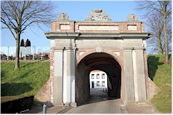 The
old walls appeared inappropriate to prevent the adversary from
taking the town, therefore a new 'full option' defence system
was designed. From now on you could only enter the town
via three (still existing) gates: the 'Graauwse Poort' (also
called Bagijnepoort), the 'Gentse Poort' (Gate to Ghent) and the
'Dubbele Poort' (Double Gate). The damaged 'Bollewerckpoort'
was partially torn down and the rest disappeared under one of
the nine new bastions. In the 20th century, remains of
that 'Bollewerckpoort' were uncovered. It was not until
1645, so by the end of the 80 Years War, that the Northern
(State) armies succeeded to capture and maintain Hulst.
Since 1648 the town was officially part of the Northern
Netherlands (what would later become the Netherlands).
The
old walls appeared inappropriate to prevent the adversary from
taking the town, therefore a new 'full option' defence system
was designed. From now on you could only enter the town
via three (still existing) gates: the 'Graauwse Poort' (also
called Bagijnepoort), the 'Gentse Poort' (Gate to Ghent) and the
'Dubbele Poort' (Double Gate). The damaged 'Bollewerckpoort'
was partially torn down and the rest disappeared under one of
the nine new bastions. In the 20th century, remains of
that 'Bollewerckpoort' were uncovered. It was not until
1645, so by the end of the 80 Years War, that the Northern
(State) armies succeeded to capture and maintain Hulst.
Since 1648 the town was officially part of the Northern
Netherlands (what would later become the Netherlands). |
©
xplorengo.com. No information or pictures can be copied or distributed in any way
without written permission of xplorengo.com.
|